So What's It Really Like On A Mountain Leader Assessment Course? #2
/WRITTEN by ANNE ENSOLL & CATHERINE MARSH
We first met Catherine Marsh in November 2019 when she completed her Mountain Leader training with us. Here she tells about her experience on her Mountain Leader assessment course in October 2021.
Photos credited to Catherine were taken during her course. Other photos were taken during other assessment courses.

Why did you decide to do your Mountain Leader assessment?
Having grown up in the Lake District I’ve always been an outdoorsy person but currently find myself working a far-more-than-full-time job as a junior doctor. In an attempt to combine these two things a little more successfully I have dreams of ending up as a Highland GP, mountain rescue volunteer and outdoor first aid trainer. For me, the Mountain Leader award is about taking a step towards this by proving I can look after myself and others in the mountains and am more than just a hospital doctor.
How did you feel as the course got nearer?
I was actually fairly calm about the whole thing. I’d done my training with Chris two years previously and had some really positive feedback, and felt I’d only got better since then, so I knew I was capable of passing. All that was blown away the evening before when the map I was supposed to be borrowing from a friend ended up being the wrong one and I had a somewhat sleepless night trying to come up with a back-up plan!
What was your first impression when you met everyone at the start of the course?
I was a whole forty minutes early and there were already four people there! But none of us had change for the car-park so we got to bond over that as our first obstacle. We were a group of seven of which five were women (a fantastic contrast from my training which was 1/10!). There were a couple of people who were teachers/working with D of E or scout groups, a ski instructor, me, and a couple who were doing it just as a personal achievement.

Photo credit: Catherine Marsh
What did you do on each day?
Monday
We set off up the side of Helvelyn on a lovely sunny day. We talked about leading groups and how to assess people’s capabilities and did a bit of balancing over rocks to demonstrate that we could stay on our feet. After walking quite a way we were asked to locate ourselves on the map (fortunately expected so this was a nice easy first tick). After this we left the path behind and headed off over some rougher ground around the base of a crag. We had a look at movement skills and did a couple of sets of pacing 100m over rocky ground. Then there was another relocate for which “somewhere along the base of the crag” was not a good enough answer.
We found a steep grassy gully through the middle of said crag and worked our way up it back to the main ridge, again looking at the way we walk, standing upright, demonstrating foot placements and pointing out the occasional interesting plant. After this we fell into the routine in which we spent most of the week - one person is given a point to lead to and on arrival the others have to work out where we are. We passed over Helvellyn and down Swirral Edge then left the path behind once more, dropping steeply into the valley and back up the other side. As we were climbing back up a shepherd and three dogs appeared and started to gather the sheep in the valley. We’d all been asked in advance to prepare an interesting mountain-based talk and mine happened to be about upland sheep farming so it was a perfect chance to watch a live demonstration and deliver that.
Back at the cars, we finished day one with a general mountain knowledge question paper. The answers were discussed as a group rather than formally marked and it was a good chance to learn a few interesting facts.

Tuesday
Day two was steep ground/rope work in Langdale. We probably only travelled a couple of miles all day but it was certainly action packed.
We set off looking again at movement skills, and spent a while on a tricky section of path trying to climb it with no hands, or without making any noise etc. We tried giving feedback to each other and worked on some coaching. After a while things got steeper and we took it in turns to lead particular sections, looking at route finding and spotting.
Things got steeper still and the rope came out and we each pitched a couple of short sections and set up anchors. There was an inevitable bit of sitting around and waiting and we got a great talk from another member of the group on the history of the Lake District National Park. My particular pitch was an awkward step which required a tactical knee and another person did actually slip on it and test my belay (fortunately it was solid!).
From here we ran out of easily pitchable crag and it was time to head down again. We did some confidence roping which turned out to be something all three of us were distinctly less confident about so our instructor did some coaching with us. We tracked backwards and forwards over a loose bit of scree so many times that we made our own paths but by the time we headed down again we’d all got it sorted as a skill.
Last but not least the gully ended in a short waterfall (luckily with not very much water) which was too steep to downclimb. There was a very convenient rock spike just at the top of it to throw the rope around and we took it in turns to do a South African abseil.
Then we were done for the day. We got some feedback from our instructor as we headed down and finished off back at the pub with an interactive talk about the science behind a few weather prediction myths/sayings and another question paper - appropriately on mountain weather.

Photo credit: Catherine Marsh
Wednesday
Day three was the start of our two-night expedition and time to lug out the big rucksack. We were in Langdale again, with the broad outline of the day being to head up and over Crinkle Crags to camp at Green Hole. We headed out along the main path then left it behind doing some short navigation steps to find tiny dips in contours etc. I got the last step to lead us up onto the tops where the weather was definitely not what was forecast (high pressure, sunshine, etc) and there was strong wind and clouds. I got the others to stay sheltered in the gully which earned me brownie points for group management and meant I could faff about in the cloud trying to find my feature without everyone else staring at me. In the end I was about 30m off and got a “close, but you can do better”.
The next leg for me was a following one. We joined the main path and walked up it and then back down it again and it started to look like our leader was slightly disorientated in the cloud. After a while they walked us towards the top of a crag and our instructor stepped in and asked us all to relocate. Error spotted, we dropped down a grassy slope instead. The next leg took us up a gully out the other side and over several small tops which I lost count of and the relocate took a while of walking around finding features, checking slope bearings and wishing it was a sunny day but I got it right in the end which was a good confidence boost. From here it was my turn to lead us down to camp and we popped out the bottom of the cloud again to see the other group heading down the slope next to us. Obviously it wasn’t a race but just for the record we won.
Down at camp we got the tents pitched and had dinner. One advantage of an October assessment is we didn’t have to wait long for it to get dark and then we headed out for some night navigation. Because it had been cloudy half the day we only had to do one leg each which was a nice bonus. We headed upstream to one point, then across through a bog to another at which point there were some confused looks. A quick heads together between two of us revealed that we’d first set off up the wrong stream and point one wasn’t where we’d been meant to be at all. It’s an odd affect of the follow-and-relocate system that, unless you have these little chats, you actually have very little idea of how your fellows are doing and whether the points you’re finding are anywhere near the points they were supposed to be taking you! The last leg was mine to contour round a little crag to a lump next to the main stream, then it was back to the tents for a well deserved night’s sleep.

Thursday
The cloud was still with us when we emerged from the tents this morning and I made an excellent job of burning my porridge while watching the cloud race across the tops. Packing up we headed off back past the features we found in the dark last night. We’d changed maps today and were on the 1:40,000 Harvey’s and doing much longer navigation legs. We headed up to a ring contour on a broad ridge, then I took us down and over a stream to a path junction at the base of Dow Crag. The stream was small enough to not pose any issues but we had a snack stop and talked through how to do river crossings if needed.
From here it was off up a gully before curling round over the top of the crag and doing a series of micro-navigation legs on some quite tricky ground to re-enter the cloud and eventually end up on top of Scafell Pike. It was slow going with gusty winds and greasy rocks underfoot though we broke it up spotting different types of moss and speculating on the geology of some interesting rocks. From here we stuck to the main ridge and feature-by-feature headed down to Angle Tarn where we were supposed to be camping. The wind was only getting stronger and there were distinct waves on the surface of the tarn so we quickly abandoned that plan! We cooked dinner while waiting for the other group then headed down into the top of Langdale where we pitched camp in extreme haste as the rain finally started to fall. Sheltering in my tent I got the welcome news that I didn’t need to demonstrate any more night nav though I did feel rather sorry for the one member of our group who had to head back out with our instructor into the pouring rain.
Friday
Sunshine! We emerged in the morning to a beautiful clear sky with the sun breaking across the valley and hardly any wind. A short walk took us back to the pub where Chris had organised bacon butties/veggie sausages as a finishing treat. Then it was time for debriefs and we all got an individual chat with our three instructors with our results (mostly passes but a couple deferred on navigation) and a chance to talk about our next steps. We were finished by 12 which left plenty of time for me to head up for a quick and very refreshing swim in Stickle Tarn and head home.
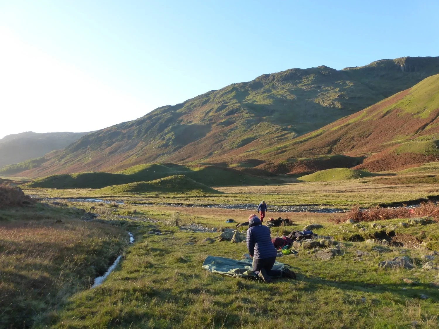
Photo credit: Catherine Marsh
What were your highlights of the course?
Many! I had a great team of fellow leaders and three very knowledgeable and patient assessors who were able to bring out the best in us. Although it was an assessment I still learnt loads, from navigational tricks and new map symbols to teaching movement skills and identifying new plants.
More specifically?
I’ll pick the relocate on Crinkle Crags where I managed to put together all the navigational skills I’d be taught to get from really disorientated to knowing exactly where I was on a lumpy hill in a thick cloud.
A surprise one here having been quite nervous about it but giving my talk. Sitting in the sun watching the sheepdogs bring in the flock and teaching people something new about an often overlooked aspect of the Lakes.
The sunrise on the last morning
What would you say to someone thinking about doing a Mountain Leader course?
It is a fantastic learning experience. I took away loads from both my training and assessment courses and would recommend them to all mountain walkers regardless of whether you need a qualification or not.
About the author

Catherine Marsh is a newly qualified mountain leader (!), hill walker, scrambler, kayaker, wild swimmer and junior doctor currently living and working in North Wales.